ブックタイトルGSIS_2019
- ページ
- 55/92
このページは GSIS_2019 の電子ブックに掲載されている55ページの概要です。
秒後に電子ブックの対象ページへ移動します。
「ブックを開く」ボタンをクリックすると今すぐブックを開きます。
このページは GSIS_2019 の電子ブックに掲載されている55ページの概要です。
秒後に電子ブックの対象ページへ移動します。
「ブックを開く」ボタンをクリックすると今すぐブックを開きます。
GSIS_2019
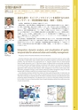
人間社会情報科学専攻Department of Human-Social Information Sciences48■研究キーワード■■KEYWORDS ■This group consists of Kuwahara laboratory and Inoue laboratory.Kuwahara laboratory deals with both theoretical and empirical researches based on various trafficsensing data to realize better urban mobility system by resolving congestion, environmental and safetyproblems. The main features of our approaches are( 1) “dynamic analysis” that can reveal essentialnature of traffic phenomena, and( 2) "data fusion analysis" of different kinds of sensing data. Specifically,we develop data fusion techniques utilizing conventional traffic detector and advanced sensing datasuch as prove vehicle, GPS mobile, bluetooth, twitter data, etc. We then apply them to the followingapplications: traffic monitoring under disasters, traffic management in local cities as well as Asian cities,information propagation through a social network, advanced mobility management using ITS. We alsodevelop traffic simulation model that can evaluate impacts of the managements.Inoue laboratory develops methods that analyze and share spatio-temporal data. In recent years, wehave gained significant access to various data, on national and local ones from the past and the present.These data would play an important role for the citizens to develop consensus and make decisions uponenvisioning regional development. This laboratory aims to nurture an information friendly environmentfor the citizens to be part of planning better future, though developing methods that enable easy accessof spatio-temporal data.Integration, dynamic analysis, and visualization of spatiotemporaldata for advanced urban and mobility management本分野は、桑原研究室と井上研究室から構成されています。桑原研究室は、災害・渋滞・環境などの諸問題の解決やより高度な交通体系を実現するために、観測データに立脚した研究を理論・実証の双方から展開しています。特に、時々刻々と変化する交通現象を“ ダイナミック” に解析し、現象の本質を明らかにしていく点、多様なセンサ情報を融合活用する点が特徴です。具体的には、従来の車両感知器に加え、プローブ車両,GPS 携帯,Bluetooth,Twitter といった移動体データ,および気象や地形データなどを積極的に融合活用する方法論を構築するとともに、実用的な研究へと展開しています。その例は、災害時の交通モニタリング,我が国地方部やアジア諸都市などインフラセンサー整備が進んでいない地域の交通モニタリング,ソーシャルネットワークにおける情報伝播,ITS先進モビリティマネジメントなどです。井上研究室は、時空間情報の解析・共有手法の開発に取り組んでいます。市民が地域の将来像を議論し合理的な意思決定を下す基となる、地域の過去から現在までを記録した詳細かつ膨大なデータが、近年利用できるようになっています。当研究室は、時空間情報の解析手法の開発を通して、「市民がデータを利用した地域の現状分析を基に将来を議論できる環境」を整備し、より良い地域づくりへと貢献したいと考えています。高度な都市・モビリティマネジメントを実現するためのセンサデータ・時空間情報の融合・解析・可視化Prof.Masao KuwaharaAssoc. Prof.Ryo InoueAssis. Prof.Yosuke Kawasaki桑原 雅夫井 上 亮川崎 洋輔教 授准教授助 教Traffic Data Analysis/ Intelligent Transport Systems( ITS)/ Traffic Flow Analysis/ Traffic Control / GIScience /Spatial Statistical Analysis交通データ解析/高度道路交通システム(ITS)/交通流解析/交通制御/空間情報科学/空間統計解析(桑原研)http://www.plan.civil.tohoku.ac.jp/kuwahara/(井上研)http://www.plan.civil.tohoku.ac.jp/inoue/Transportation and Geographic Information Science空間計画科学左: プローブ、気象データ等のリアルタイム可視化右: 災害時の通行障害の事前アラートシステムLeft: Real time visualization of probe and weather data 不動産価格情報提供サービスの提案Right: In advance alert of traffic failure under disasters Proposal for information service of real estate property values