ブックタイトルGSIS_2019
- ページ
- 23/92
このページは GSIS_2019 の電子ブックに掲載されている23ページの概要です。
秒後に電子ブックの対象ページへ移動します。
「ブックを開く」ボタンをクリックすると今すぐブックを開きます。
このページは GSIS_2019 の電子ブックに掲載されている23ページの概要です。
秒後に電子ブックの対象ページへ移動します。
「ブックを開く」ボタンをクリックすると今すぐブックを開きます。
GSIS_2019
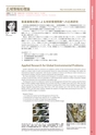
16情報基礎科学専攻Department of Computer and Mathematical Sciences■研究キーワード■■KEYWORDS ■IKONOS image fusion process usingVisualization for air pollution and Asian dust image obtained from Aqua-MODIS observed on 12, 13 steepest decent method.and 14 August 2015. The air pollution after Tianjin explosions is drifting toward the Korean Peninsula.最急降下法を用いたIKONOS 画像の融合処理2015 年8 月12 日(上)と13 日(中) 14 日(下)のAqua-MODIS 画像より、越境大気汚染(黄色)と黄砂(赤色)を抽出した画像。中国天津大爆発前、後、その後を発生源とする汚染物質が朝鮮半島に向かって動き始めている様子が大変よく分かる。Kudoh Laboratory aims to construct an academic system of the Environmental Informatics and tomake an unique study of earth environmental theme by using Information Technology. We realize theinternational research cooperation with Russian Academy of Science and Moscow State University as atotal research strategy. Domestic research laboratories also participate.We have developed a three-dimensional histogram to analyze satellite images that consisted of anumber of spectral data. And we extended to multi-dimensional method to obtain extraction reliableresults of the aerosols such as air pollution and yellow sand.The Research Unit for CO2 Reduction System by the Management of Forest Fires is going. And the HomePage of NOAA satellite image database was accessed more the 3.3 million every year since 1990. And alsowe are opened the Trans-boundary Air Pollution including PM2.5 from China Satellite Image Database(https://tapsidb.cneas.tohoku.ac.jp). More than 2,700 users already use it. We start the other satellites,MODIS, MTSAT and NPP direct readout. Besides the research of image fusion processing for less than 1 mresolution satellite images is in progress.Research Theme:1. CO2 Reduction System by the Management of Forest Fire2. Development of image fusion algorism for 1m satellite data3. Construction of a system of large-size image database4. Visualization for China's pollution and Asian dust by MODIS imagesApplied Research for Global Environmental Problems本研究室は環境情報科学の学術体系の構築を目指し、地球環境課題について情報通信技術を取り入れた研究開発を行っています。研究戦略としてロシア科学アカデミーとモスクワ大学との国際共同研究の体制をとり、国内研究機関も参画する共同研究を実施しています。これまでに、多数のスペクトルデータから構成する衛星画像を解析するために3次元ヒストグラムを開発しました。この方法を多次元化に発展させ、大気汚染や黄砂抽出などのエアロゾル抽出により信頼性の高い成果を得ています。現在は、森林火災から発生するCO2 削減システムに関する研究に取り組んでいます。これまでの研究は火災から発生する熱を火災として検出していましたが、火災初期の煙の検出に挑んでいます。また、画像データベースは1990 年から毎日のノア画像をホームページから提供し、毎年330 万件以上のアクセスがあります。さらに、中国からのPM2.5 を含む越境大気汚染衛星画像データベースを公開(https://tapsidb.cneas.tohoku.ac.jp)しています。既に、2,700 名以上の利用者がおります。研究室ではMODIS,MTSAT, NPP の直接受信も行っています。その他、解像度1m クラスの衛星画像を対象とした融合画像処理の研究も展開しています。主な研究テーマ:1.森林火災から発生するCO2 削減システムに関する研究2.高分解衛星画像の融合処理研究3.大規模衛星画像データベース構築4.衛星画像を用いた中国からの大気汚染・黄砂の可視化衛星画像処理による地球環境問題への応用研究Prof.Jun-ichi Kudoh工藤 純一image fusion / visualization for air pollution / Forest Fire / CO2 reduction画像融合処理/大気汚染可視化/森林火災/ CO2 削減http://www.kudoh.cneas.tohoku.ac.jp/Environmental Infomatics広域情報処理論教 授